National Hurricane Center director: Changes coming for upcoming hurricane season
A tropical weather product originally unveiled to the public in 2017 is receiving a major upgrade in 2025 that the National Hurricane Center believes will help communities prepare for impacts. According to the agency, its meteorologists will now have the ability to issue forecasts for potential tropical cyclones up to 72 hours before impacts begin – an increase of 24 hours compared to the previous usage of the product.

Kentucky braces for land shifts following deadly winter storm
Authorities in the central region of the Blue Grass State are warning that the impacts from a deadly winter storm are continuing, with sections of riverbanks seen collapsing over the last several days. Franklin County Judge Executive Michael Marler stated that the damage is directly linked to the rapid recession of the waters, causing some cliffs along the waterways to erode and give way. "But what's most worrisome is this riverbank. As you can see here, the riverbank has given way, and that is because it is receding way too fast. So I want to keep everybody safe. If you live near the river, be aware of this. If you're just walking around looking at things, please be aware of this too," Marler said in a social media post.

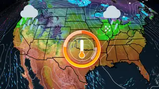
Temperature Roller Coaster
Excited for the warmup this weekend? Well, enjoy those temps while you can because they won’t last long. Temperatures will rise above average across the country through early next week, so take advantage and spend that time outdoors. Come Thursday, temperatures will start to dip back down as winter is not giving up so easily. Time out the temperature roller coaster here.

Warmup This Week: Fool’s Spring Or The Real Thing?
Although the above-average temperatures this week will be perfect for getting a reprieve from cabin fever, be warned - it’s not time to get out in the garden yet. On average, much of the country has not experienced its last freeze of the season. However, high temperatures reaching into the 60s and 70s across much of the southern tier will be perfect for getting outside. Winter continues to linger though, with chilly lows and a return to average temperatures late this week. Time it out here.

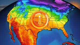
Temperatures Soar Above Average, But For How Long?
The weekend warmup will continue into early week across much of the country - a treat for those antsy to get outside after the brutal cold blast last week. Places like Kansas City and DC will creep into the 60s while places like Dallas, New Orleans and Atlanta will soar into the 70s. But the above average temperatures will not last through the week for many along the East Coast. Time out the temperature roller coaster here.
Warmup This Week: Fool’s Spring Or The Real Thing?
Although the above-average temperatures this week will be perfect for getting a reprieve from cabin fever, be warned - it’s not time to get out in the garden yet. On average, much of the country has not experienced its last freeze of the season. However, high temperatures reaching into the 60s and 70s across much of the southern tier will be perfect for getting outside. Winter continues to linger though, with chilly lows and a return to average temperatures late this week. Time it out here.
Weather This Week: 3 Things To Watch
Multiple shots of rain and snow will move through the Great Lakes and Northeast this week. Much of the country will continue to see temperatures soar well above average. Rain and mountain snow will start the week in the Northwest, causing an increased flood threat. Here’s what we’re watching this week.

Spring Differences Between 2025 vs. 2024
Meteorological Spring begins this weekend, and there are definite similarities and differences from last year. Here our spring weather forecast may look like.

Pacific Northwest braces for wet weather
Days of rain are on the way for the Pacific Northwest.

Pacific Northwest could get more rain in two days than the rest of February
A pair of storms pummeling the Pacific Northwest are expected to dump more rain in two days than some areas have seen the entire month so far, threatening avalanches in mountain areas and flooding and power outages throughout the Washington-Oregon border region. The system also poses the risk of so-called “sting jets,” atmospheric phenomena in which intense winds develop beneath low-pressure systems with the chance for extensive wind damage.